The Latest: Tornados spawned by Nestor damages homes

MIAMI (AP) — The Latest on Tropical Storm Nestor (all times local):
NOON
A second suspected tornado spawned by Tropical Storm Nestor has damaged homes in southwest Florida.
The Cape Coral Police Department said in a statement that about dozen homes were damaged Saturday morning by a possible tornado, some severely. No injuries were reported.
The Polk County Sheriff's Office said a tornado damaged about a dozen homes and a school near Lakeland late Friday. No serious injuries were reported.
The National Hurricane Center in Miami said late Saturday morning that Nestor was no longer a tropical storm, but still had strong wind gusts and was creating storm surge on some beaches. Its top sustained winds of 50 mph (80 kph) and was moving northeast at 9 mph (14kph) as it neared the Panhandle.
___
11:15 a.m.
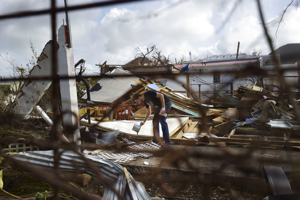
A tornado spawned by Tropical Storm Nestor damaged homes and a school in central Florida but the storm spared an area of the Florida Panhandle devastated one year ago by Hurricane Michael.
The Polk County Sheriff's Office said Saturday several homes and a school were damaged when the tornado hit late Friday near Lakeland, about an hour's drive southwest of Orlando. Sheriff Grady Judd said no one was injured.
Meanwhile, Mexico Beach Mayor Al Cathey said his Panhandle town got some much needed rain but no damage from the storm. Hurricane Michael nearly destroyed the town one year ago. He said the town was "fortunate."
The National Hurricane Center in Miami said late Saturday morning that Nestor was no longer a tropical storm, but still had strong wind gusts and was creating storm surge on some beaches. Its top sustained winds of 50 mph (80 kph) and was moving northeast at 9 mph (14kph) as it neared the Florida Panhandle coast near Mexico Beach.
___
5 a.m.
Storm surge and winds are lashing much of Florida's Gulf Coast as Tropical Storm Nestor approaches.
But the National Hurricane Center in Miami says Nestor is gradually losing its tropical characteristics. By early Saturday morning, the storm was centered about 85 miles (137 kilometers) south-southwest of Panama City, Florida. It had top sustained winds of 50 mph (80 kph) and was moving northeast at 17 mph (27 kph).
Nestor was expected to move inland over the Florida Panhandle later Saturday morning, and then move across parts of the southeastern U.S. on Saturday and Sunday. It's expected to move offshore of the coast of North Carolina and into the western Atlantic Ocean by late Sunday.
The storm's expected to further weaken once it moves inland, and is forecast to become a post-tropical cyclone later Saturday. A tropical storm warning west of the Okaloosa/Walton County line in Florida has been discontinued.
___
11 p.m.
Rain from Tropical Storm Nestor is lashing Florida's Gulf Coast as the storm continues to race toward the Florida Panhandle.
On Friday night, the National Hurricane Center said the storm was centered about 140 miles (225 kilometers) southwest of Panama City, Florida. It had top sustained winds of 60 mph (95 kph) and was moving to the northeast at 23 mph (37 kph).
Forecasters expect storm surge and winds to increase along the Gulf Coast on Saturday.
A tropical storm warning is in effect from Navarre to Yankeetown in the Florida Panhandle and a storm surge warning extends from Indian Pass to Clearwater Beach, Florida.
Forecasters say Nestor will race inland over the Florida Panhandle on Saturday morning and weaken as it moves across parts of the U.S. Southeast over the weekend. It's expected to travel over the North Carolina coast into the Atlantic by Sunday.
___
7 p.m.
Heavy rains are spreading over parts of the U.S. Gulf Coast as Tropical Storm Nestor approaches the Florida Panhandle.
The National Hurricane Center says Nestor was centered Friday evening about 215 miles (340 kilometers) southwest of Panama City, Florida. The storm's moving to the northeast at 22 mph (35 kph) and has top sustained winds of 60 mph (90 kph). A tropical storm warning is in effect from Navarre to Yankeetown in the Florida Panhandle and a storm surge warning extends from Indian Pass to Clearwater Beach, Florida.
Forecasters say Nestor will race inland over the Florida Panhandle on Saturday morning and move across parts of the U.S. Southeast over the weekend before moving off the North Carolina coast into the Atlantic by late Sunday.
The hurricane center says Nestor could strengthen a little in coming hours but is expected to weaken after it moves inland.
___
4:20 p.m.
Forecasters say Tropical Storm Nestor is zeroing in on Florida as it moves across the Gulf of Mexico.
The National Weather Service has scaled back on a tropical storm warning that extended all the way to parts of Louisiana and the Alabama-Mississippi state line.
The smaller warning area stretches in Florida from Navarre in the Panhandle to Yankeetown on the state's western coast.
Forecasters said at 4 p.m. Friday that the system was about 150 miles (240 kilometers) southeast of the mouth of the Mississippi River. It had top sustained winds of 60 mph (95 kph) and was moving to the northeast at 22 mph (35 kph).
___
4 p.m.
The mayor of Mexico Beach says the city that was nearly washed off the map by Hurricane Michael isn't nearly as concerned about Tropical Storm Nestor.
As Nestor makes a path toward the Florida Panhandle town, Mayor Al Cathey said there's little activity in terms of storm preparation.
Michael came ashore last year as a Category 5 hurricane and wiped out much of Mexico Beach.
This year the area has been more affected by a weeks-long drought. Cathey says, "A little rain is welcome."
He says he sees nothing in the forecast that should make people alarmed.
___
2:10 p.m.
Officials are warning about dangerous conditions along Gulf Coast beaches as Tropical Storm Nestor moves northward across the Gulf of Mexico.
The Coast Guard says seas could reach 20 feet (6 meters) in height around Panama City, Florida. And dangerous rip currents are possible along the coast as Nestor approaches land Friday and Saturday.
A storm surge warning also is in effect for the eastern Florida Panhandle and the state's Big Bend region north of Clearwater.
A shelter is opening near Panama City in Bay County, where some people are still struggling more than a year after Hurricane Michael devastated the area.
___
12:45 p.m.
Forecasters say a disturbance moving through the Gulf of Mexico has become Tropical Storm Nestor.
The National Hurricane Center says high winds and dangerous storm surge are likely along parts of the northern Gulf Coast.
Conditions are expected to deteriorate Friday into early Saturday.
Forecasters said at 1 p.m. that the system was about 195 miles (315 kilometers) south of the mouth of the Mississippi River. It had top sustained winds of 60 mph (95 kph) and was moving to the northeast at 22 mph (35 kph).
___
11 a.m.
Weather forecasters say a storm system is strengthening as it moves toward the U.S. Gulf Coast.
The National Hurricane Center in Miami said dangerous storm surge, heavy rain, and high winds were likely to reach portions of the northern Gulf Coast starting later Friday and lasting into the weekend.
Forecasters said at 11 a.m. that the system was about 230 miles (365 kilometers) south-southwest of the mouth of the Mississippi River. It had top sustained winds of 60 mph (95 kph) and was moving to the northeast at 22 mph (35 kph).
A tropical storm warning was in effect from the Mississippi-Alabama line to Yankeetown, Florida, and from Grand Isle, Louisiana, to the mouth of the Pearl River. That means tropical storm conditions are expected somewhere within the warning area.
The combination of a dangerous storm surge and the tide could result in normally dry coastal areas flooding.
___
A weather disturbance moving toward the Southern United States with heavy rain and wind is expected to become a tropical storm Friday as it nears the Gulf Coast, forecasters said.
The disturbance, which would be named Nestor, should bring a wet weekend across much of the drought-parched Southeast, where some events were being canceled and officials were trying to calm fears of a hard hit.
Forecasters said the system was about 390 miles (630 kilometers) south-southwest of the mouth of the Mississippi River. It had top sustained winds of 40 mph (65 kph) and was moving to the northeast at 14 mph (22 kph).
A tropical storm warning was in effect from the Mississippi-Alabama line to Yankeetown, Florida, and from Grand Isle, Louisiana, to the mouth of the Pearl River.
Forecasters expect blustery winds and heavy rain in parts of Alabama, Georgia and northern Florida, reaching the Carolinas and Virginia by Sunday.
In New Orleans crews were preparing to explode two badly damaged construction cranes that are towering over a partially collapsed hotel project at the edge of the French Quarter. They planned to bring the cranes down Friday just ahead of winds that could cause them to tumble out of control.
High schools from Alabama to the eastern Florida Panhandle canceled or postponed football games scheduled for Friday night, and officials in Panama City tried to assure residents that the storm wouldn't be a repeat of Category 5 Hurricane Michael last year.
"We are optimistic this will be a slight wind and rain event," said Bay County Sheriff Tommy Ford.
The system could dump from 2 to 4 inches (5 to 10 centimeters) of rain from the central Gulf Coast to the eastern Carolinas, where many areas are dried out from weeks without rain, and as much as 6 inches (15 centimeters) in spots, forecasters said.
Seawater pushed inland by the storm could rise as much as 5 feet (1.5 meters) as storm surge in Florida's Big Bend region, much of which is less-developed than the rest of the state's coast.